Sikkim flood was one of Asia’s worst climate disasters in 2023 Premium
The Hindu
The 2023 Sikkim glacial outburst flood was one of the worst climate-related disasters to have occurred in Asia in the year. Climate change-induced glacier retreat makes such disasters more common.
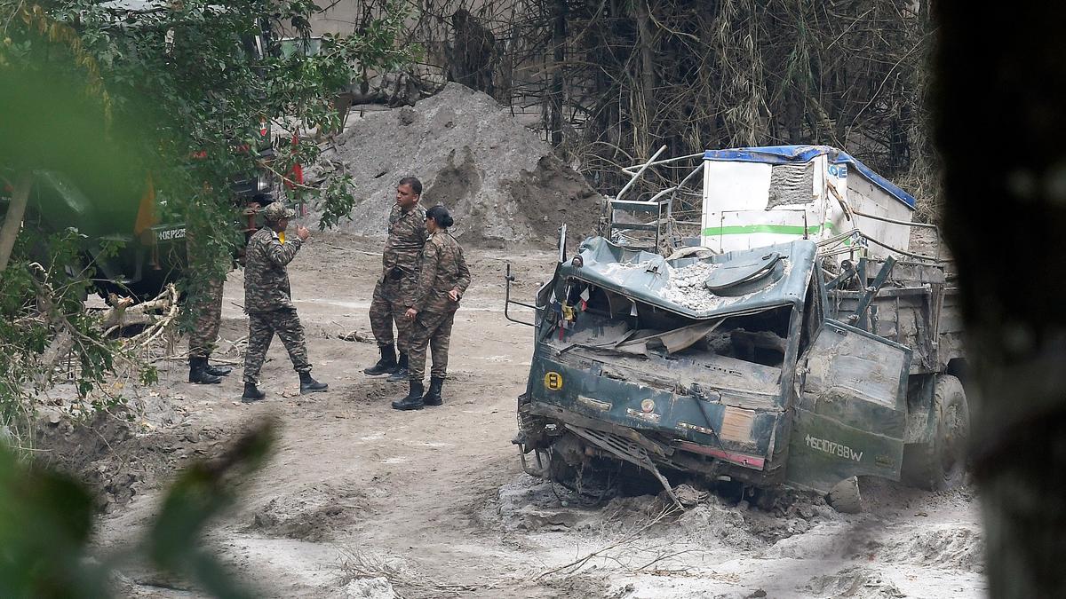
A glacial lake outburst flood in Sikkim in October 2023 led to the collapse of the Teesta III hydroelectric dam, killed more than 100 people, and affected thousands of others. And according to the World Meteorological Organisations ‘State of the Climate Asia 2023’ report, published in April, it was one of the worst climate-related disasters to have occurred on the continent last year.
A body of water influenced by glaciers is called a glacial lake. As glaciers move, they erode the land underneath and the debris of rocks and soil scraped from the land from ridges called moraines. Glacial lakes are mostly on the margins of glaciers and evolve from ice-contact lakes — where the lake is in touch with the ice — into distal lakes as the glaciers retreat.
Moraines or ice blocks can form natural boundaries that hold back water and convert it into lakes. A glacial lake outburst flood (GLOF) happens when this holding structure becomes weaker, allowing the water to rapidly gush out., causing downstream flooding.
Glacial ice is sensitive to changes in regional temperature, precipitation, and surface radiation. When glacial ice melts, it affects sea level, regional water cycles, and creates hazards like GLOFs. The High-Mountain Asia region, centred on the Tibetan plateau, holds the largest volume of ice outside the polar regions.
Early on October 4, a breach in Sikkim’s South Lhonak resulted in a GLOF. The Teesta III dam – Sikkim’s biggest hydropower project – was located 60 km away at Chungthang. The GLOF destroyed the facility and rendered significant destruction downstream.
Satellite images in the aftermath from the National Remote Sensing Centre suggested around 1 sq. km of the glacier-fed lake had been drained, compared to its volume on September 28. These images didn’t reveal lake’s depth, however. In a press release published after the disaster, the National Disaster Management Authority (NDMA) cited the Central Water Commission’s monitoring stations to say the first surge of water was 19 m above the maximum water level at Sangkalang at 1.30 am and 4 metres above the maximum level at Melli at 4 am.
A few weeks later, GLOF expert and IIT Bhubaneswar assistant professor Ashim Sattar said a GLOF-triggered landslide had blocked the river channel 30 km downstream of the lake, resulting in a new lake. And although the new lake “drained partially through a channel beneath the landslide debris, [it] still exists and needs regular monitoring,” Dr. Sattar said in a post on X.

Government removes roadside encroachments in Puducherry's Bharathi Street to improve traffic, traders protest, removal put on hold temporarily.

Minister for Local Self-Governments M.B. Rajesh distributed the Swaraj Media Awards at Guruvayur on Wednesday. S.R. Praveen, Principal Correspondent, The Hindu, received the Swaraj Media Award (Print Media) for his report “Foot soldiers of Kerala’s silent revolution against waste.”

AIMIM urges Maharashtra government to allow Muslim employees and students to leave an hour early during Ramzan.

Samsung India Workers Union (SIWU) plans a massive strike on March 7 over suspended workers, amid ongoing negotiations with management.

Health Minister inaugurates development projects worth ₹1.60 crore in Virugambakkam, Chennai funded by MP and MLA.

Uttar Pradesh jails to bring holy water from Maha Kumbh to all prisons for inmates to participate.

NGT criticizes UPPCB for lack of data on faecal coliform levels in Ganga and Yamuna rivers during Maha Kumbh.

Voorhees College wins All India Football Tournament at VIT's Riviera-2025, with principal congratulating team.

Retteri lake restoration project near completion, increasing storage capacity for fresh water supply in Chennai by next monsoon.

Delhi High Court advocates understanding over punishment in cases of adolescent love, prioritizing safety and well-being of young individuals.

Congress president Mallikarjun Kharge emphasizes accountability and strengthening party organization in a meeting with AICC office-bearers.

Karnataka High Court upholds ₹1.28 crore compensation ruling for victims of electricity accidents, including minors, during 2017-18.

Residential building in Thippasandra tilts in East Bengaluru, occupants narrowly escape; authorities take swift action to prevent further damage.