


Myanmar earthquake: Satellite images show extent of devastation across Mandalay, other cities
The Hindu
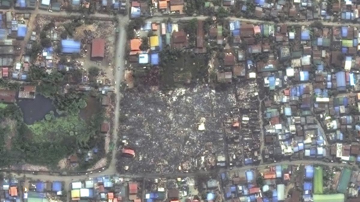
Satellite images show effects of deadly 7.7 magnitude earthquake in Myanmar which has caused widespread devastation, with over 1,600 lives lost and international aid efforts underway.
On March 28, 2025, a major 7.7 magnitude earthquake originated near Mandalay, Myanmar, and shook the Earth as far as Bangkok, about 1,300 kilometers away With aftershocks still rattling the city at the epicentre, the country has lost over 1,600 lives and this number is expected to go up.
Myanmar earthquake updates: March 30, 2025
Following the severe tremors, Mandalay residents found their city infrastructure ravaged. The deadliest natural disaster to hit Myanmar in years damaged critical infrastructure, including an airport, highways and bridges.
Another hard-hit city in Myanmar suffered extensive damage, with images from the capital, Naypyidaw, showing rescue crews pulling victims from the rubble of collapsed buildings.
Satellite photos now show the brutal aftermath of the disaster.
With damage to the Naypyitaw International Airport, fights carrying rescue teams from India and China have landed at the airport in Yangon instead of going directly to the airports in the major stricken cities of Mandalay and Naypyitaw.
Also read | Myanmar earthquake: Aftershocks rattle Mandalay as rescuers search for survivors
 Run 3 Space | Play Space Running Game
 Traffic Jam 3D | Online Racing Game
 Duck Hunt | Play Old Classic Game
Minister Velu updates Tamil Nadu Assembly on progress of Chennai Port-Maduravoyal elevated corridor project, addressing delays and measures taken.

Delhi High Court expresses concerns over infighting in sporting federations, urges resolution to avoid disqualification by international bodies.

ASR District Collector grants forest permission for road construction in hilltop hamlets, resolving tribal people's protest.

Kolkata college principals protest University of Calcutta's decision on PG exams, demanding consultation and fair governance in higher education.

Government committees discuss amendments to Atomic Energy Act and CLNDA to allow private companies in nuclear sector.

Madras High Court appoints senior advocate to investigate dispute over examination date between University of Madras and student.

Kerala CPI(M) party congress discusses challenges and achievements, emphasizing unity of Left parties and welfare over growth.

Baby Eva sleeps peacefully at CPI(M) congress, while folk artistes, orators, and 'Comrade Gangsta' add zest to the event.

The Telangana Chief Minister demanded that Mr. Modi step down from his post if he does not endorse the hike in quota.

Residents, school children, shopkeepers, and representatives of several social organisations staged a protest in Brahmavar of Udupi district on Wednesday demanding a flyover and service roads on NH 66.

Unique anti-fascism photo exhibition captures Auschwitz horrors, drawing parallels to current Indian political climate, touring major cities.

KWA infrastructure works in Thiruvananthapuram cause water supply disruptions, expected to be restored by Friday 8 a.m.

Slow two-way movement of vehicles on one side of the Nethravati bridge, on National Highway 66 at Jeppinamogaru resulted in traffic jam between Thokkottu and Pumpwell on Wednesday evening.