‘Take up work on Thiruneermalai Periya Eri, Nattu Kalvai on a war footing’
The Hindu
It is the Thiruneermalai Periya Eri Paathukappu Kuzhu’s plea that the Chief Minister prioritise this project and sanction it so that work could be executed during summer and residents are spared flooding during NE monsoon
Thiruneermalai Periya Eri is a supersized waterbody lying spread-eagle and claiming pieces of three wards (29, 30 and 31) within Tambaram Municipal Corporation limits. This waterbody has a neighbour, only a few addresses removed, named Veeraraghavan Eri.
During NE monsoon, the connectedness between these lakes stands out in bold relief.
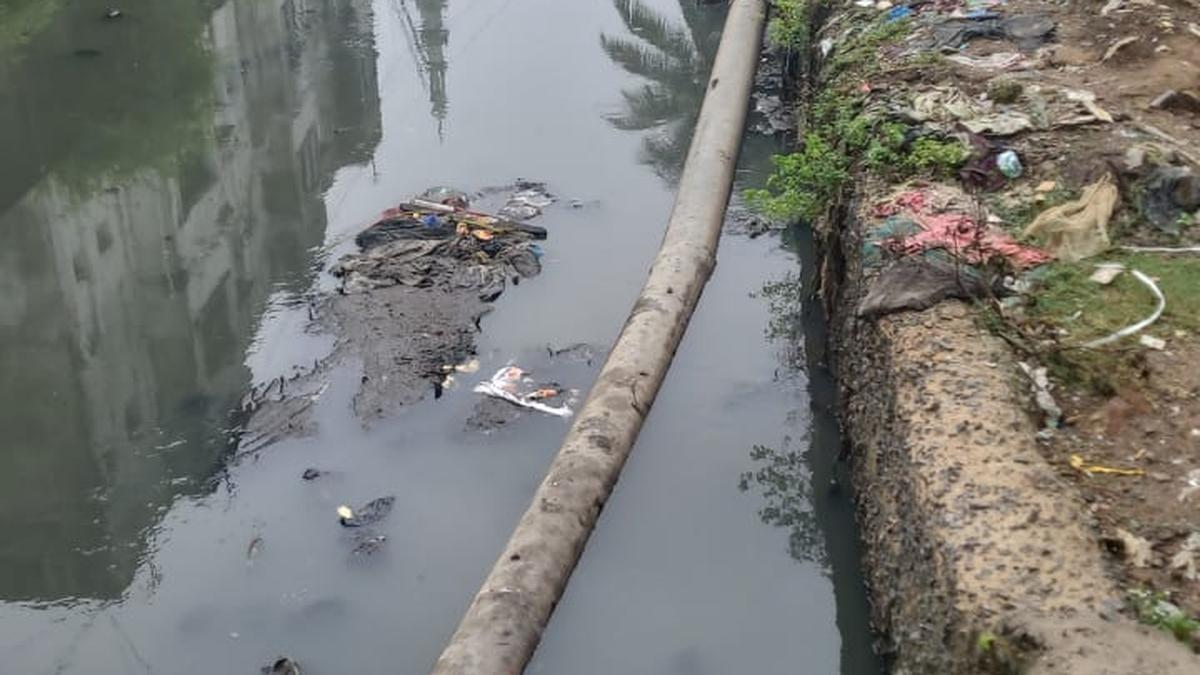
Pachai Malai, a dwarfish hill in Tambaram Sanatorium, “supplies” rainwater to Chitlapakkam Lake on its east and Veeraraghavan Eri on its west. Filled-up, Veeraraghavan Eri disgorges rainwater, which gushes into Tiruneermalai Periya Eri. Thiruneermalai Periya Eri spits out the excess water into a rainwater-carrying channel called Nattu Kalavi, which courses through residential areas, slithers under the Maduravoyal-Irumbuliyur Bypass Road and meets Adyar river. The course of Nattu Kalvai being beset with challenges, neighbourhoods on both sides of it face flooding during NE monsoon, says B. Saravanan, a resident of Thiruneermalai and a member of Thiruneermalai Periya Eri Paathukappu Kuzhu and a social activist, while presenting this graphic picture to nail the rainwater-flow dynamics of the region.
Prominent members of Thiruneermalai Periya Eri Paathukappu Kuzhu, including Perumal, Arulmozhi, Kumaran and Saravanan are in the forefront of a drive to have residents’ concerns about flooding in these parts heard by officials in government line agencies that can reverse this situation. On May 4 and July 28, both in year 2024, the group organised a clean-up drive at Thiruneermalai Periya Eri and an awareness rally around the issue respectively.
Saravanan continues: “If you imagined a funnel, you would gain a mental picture of Nattu Kalvai. Where the Nattu Kalvai nuzzles close to Thiruneermalai Periya Eri, it is 60 feet wide, serving as a Kalangal, a catchment area for water overflowing from the lake.”
And a 50-metre amble later, when it crosses over to the other side of Thiruneermalai Main Road, it appears emaciated, reduced by half (just 30 feet wide now), as if it had been through an ill-advised diet plan.
“When it crosses Saraswathipuram First Street, it would be 20 feet wide, and while running parallel to Saraswathipuram Fourth Street Extension, it gets narrower still, slimming down to 15 feet. It heads to Ranga Nagar Third Street, followed by an area called Temple Town; after which it would run near the entrance of a massive gated community, Jain Alpine Meadows, and 300 metres further, it touches the Maduravoyal-Irumbuliyur Bypass Road, which comes under NHAI. Before it reaches the bypass road, it gets slightly wider, and its movement towards Adyar river on the other side is enabled by a box culvert under the bypass road. The flow of rainwater through Nattu Kalvai in this part is hampered by the presence of a pipeline of four-feet diameter pertaining to the Veeranam water supply scheme, which comes under the State government. The pipeline crosses Nattu Kalvai, slowing down the rainwater flow in the latter,” says Saravanan.

ASHAs in Kerala intensify agitation at government Secretariat, demanding basic rights and fair wages, drawing national attention.

Dive into the intriguing world of actor Gulshan Devaiah, where talent meets versatility

Kerala High Court rules in favor of Kerala Waqf Land Samrakshana Vedi, State government likely to challenge decision.

PM Modi podcast: ‘Multilateralism needs reforms but does not deserve wholesale condemnation of the type President Trump and Prime Minister Modi are indulging in,’ the Congress leader said

Kerala Police investigates ₹281.43 crore fake CSR funds scam promising discounted scooters, laptops; 665 cases with Crime Branch.

BJP appoints 70 district presidents in Uttar Pradesh, focusing on caste balance for 2027 assembly polls.

As the mercury is going up day by day, rural areas in the district may face drinking water problems in the next three months.

Kerala High Court quashes State government's appointment of inquiry commission, citing lack of consideration and legal restrictions.

He recalled that K.H. Patil was the chairperson of the committee that officially declared the State as ‘Karnataka’.

Tamil Nadu BJP leaders arrested by Chennai police ahead of TASMAC protest over financial irregularities.

Mumbai Customs seizes 10 kg gold worth ₹8.47 crore at airport, arrests five including private staff for smuggling.

Delhi's weather: 16.8°C min temp, 32°C max temp, 74% humidity; AQI 99 'satisfactory'; CAQM lifts GRAP restrictions.

60-year-old man dies after falling into overflowing drainage in Kozhikode, Kerala; rescue squads recover body after 10-hour search.