Shifting sands
The Hindu
Tamil Nadu's coastline faces erosion due to climate change, prompting the need for innovative solutions for coastal protection.
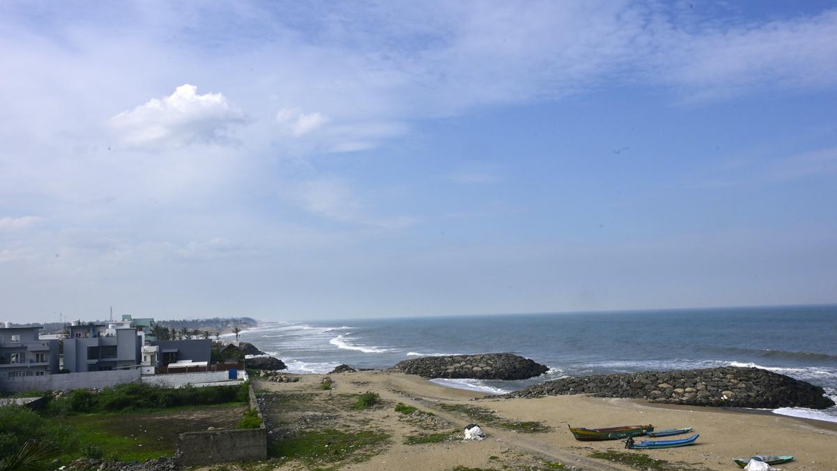
Tamil Nadu, with the second longest coastline in India at 1,076 kilometres, has long thrived on its rich maritime heritage. Its coast has been the cornerstone of the State’s prosperity for ages. Yet, as climate change drives up the sea level, the boundary is shifting between the land and the sea.
Erosion eats away at the coast, threatening the livelihood of fishers and others who have made their homes there. Development projects, intended to bolster economic growth, and ‘solutions’ to prevent sea erosion are only worsening the situation by altering the shoreline and compounding the challenges faced by local communities.
To deal with sea erosion, it is crucial to understand how the coast erodes in Tamil Nadu and examine the specific vulnerabilities of the State’s coastline. Sea erosion happens when the shoreline wears away by the movement of sand and water. In Tamil Nadu, for most of the year (about eight months), the wind and the sea current flow from the south to the north, carrying sand along with them. During the northeast monsoon (for about four months), they reverse their direction.
When hard structures like ports, breakwaters, or groynes are built extending to the sea, they block the natural movement of sand. As a result, sand piles on one side of these structures, and the opposite side loses sand and begins to erode. This imbalance accelerates coastal erosion on the side where sand is no longer deposited, causing waves to advance further inland and increasing the risk to the coastal areas.
A study conducted by Anna University’s Centre for Climate Change and Disaster Management reveals that 76% of the coastline in Chennai, Tiruvallur, and Chengalpattu, running to 102.2 km, is at risk from cyclones, coastal erosion, and the sea level rise. Tiruvarur, Nagapattinam, and Chengalpattu are especially vulnerable, owing to high salinity and low elevation. Over 60% of the coastline in Kanniyakumari, Chennai, and Cuddalore is also exposed to climate change, influenced by land use and infrastructure.
The National Centre for Coastal Research (NCCR) reports that 422.9 km (42.7%) of Tamil Nadu’s mapped coastline of 991.4 km is facing erosion, exacerbated by hard structures such as groynes, jetties, and piers, with the number of these structures increasing since 2022. Tiruvallur and Kanniyakumari have the largest proportion of their coastal areas occupied by ports, harbours, and coastal protection structures, according to the NCCR. Over the past five years, the fisherfolk of Karikattukuppam, a coastal hamlet near Muttukadu in Chengalpattu district, have observed the sea inching closer to their homes. During cyclonic storms and on full and new moon days, they have had to watch over their boats and fishing gear. This situation is common in several villages across Chengalpattu.
In response to the fishing community’s concerns, the Fisheries Department in 2023 applied its standard solution: groynes. Unfortunately, this approach has led to significant challenges for villages north of Karikattukuppam, like Reddy Kuppam in Kanathur. Fisherfolk of Reddy Kuppam have had to move their boats to Karikattukuppam, where two groynes offer temporary shoreline protection.

Canada to impose 25% tariffs on $155 billion of U.S. goods if Trump's tariffs on Canadian goods proceed.

The city’s civic body is all set to serve notices for recovery of long-pending service charges for prominent government buildings in the city, including Vidhana Soudha, that houses the State’s Secretariat and has an outstanding of ₹6.3 crore, as per Bruhat Bengaluru Mahanagara Palike’s (BBMP) data.

Over 4.27 lakh students begin SSLC and Plus Two exams in Kerala, with various subjects and exam centers.

Discussion on major development projects, including drinking water, drainage, and parking systems, at the District Development Coordination and Monitoring Committee meeting.

Water Resources Minister Nimmala Ramanaidu has stated that Godavari Pushkaralu will be conducted from July 23 to August 3, 2027.

Rising obesity rates in India, particularly among women in South Indian States, highlighted with BMI data and PM Modi's advice.

Special educator Soumya Devadiga selected as coach for Indian team in Special Olympics Winter Games in Italy.

Gade Srinivasulu Naidu wins North Coastal Andhra Pradesh Teachers' Constituency election with overwhelming support from teachers.

Congress alleges BJP government in Madhya Pradesh plans to privatise 40% of forests, displacing tribals from their habitat.

Tamil Nadu Governor R.N. Ravi advocates renaming Indus Valley Civilization to Saraswathi Civilization, challenging historical narratives.

A study by researchers from NIMHANS, in collaboration with doctors from Australia, United Kingdom and some states in India, has found suicidal ideation and suicide attempts alarmingly high among college students across the country.

First trial run of disposing 10-tonne Union Carbide toxic waste in Pithampur begins after Supreme Court's decision.

Telangana tunnel collapse rescue updates: Follow the Hindu’s updates as Srisailam Left Bank Canal tunnel rescue operations enter the 11th day