Rapid urbanisation of Chennai Metropolitan Area will shrink waterbodies, reduce groundwater recharge potential, says study
The Hindu
Anna Univ. study finds urbanisation in Chennai Metro Area to reduce agricultural lands, waterbodies, and groundwater recharge potential in next 4 decades. Built-up area to increase from 656 sq.km in 2021 to 864 sq.km by 2101. Agricultural lands to drop from 346 sq.km to 289 sq.km by 2051. Waterbodies to decrease from 153 sq.km (13%) to 145 sq.km (10%) by 2101. Measures needed to balance urbanisation, such as protecting lake boundaries, promoting rainwater harvesting, etc.
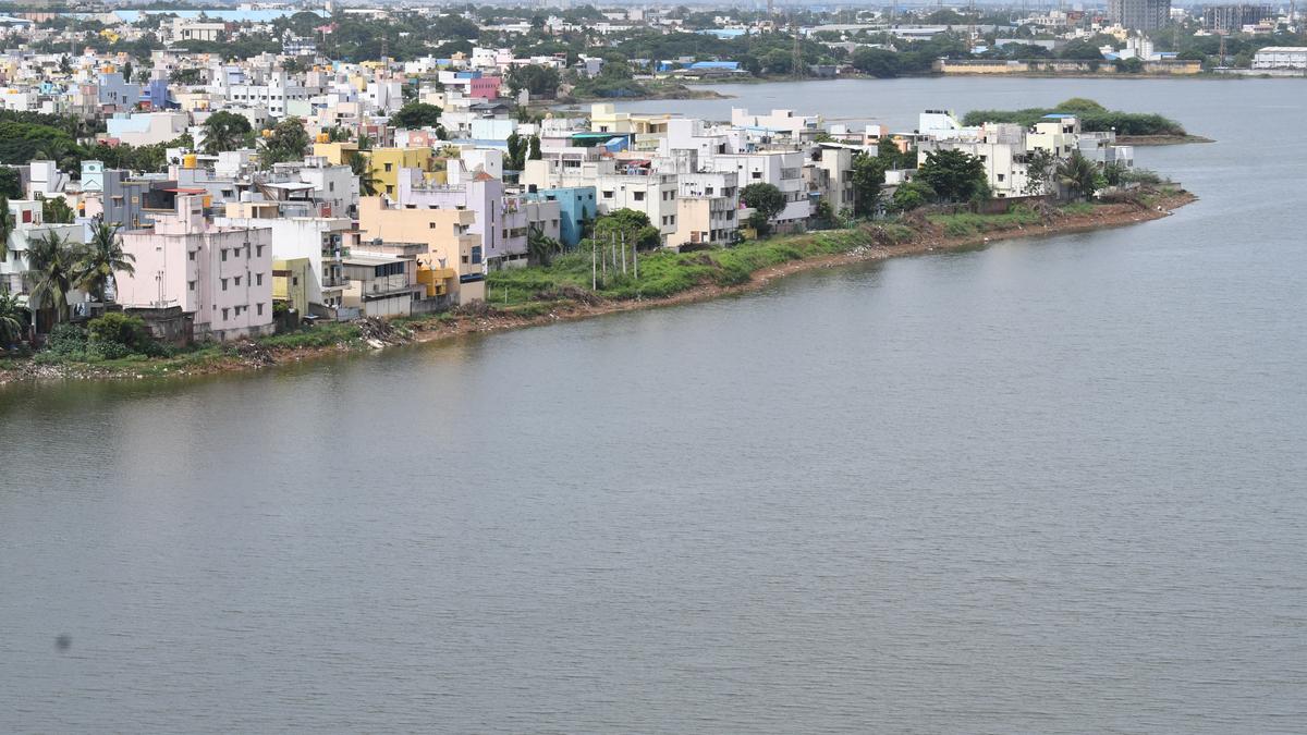
In the next four decades, tremendous changes in land use and increase in built-up area in the Chennai Metropolitan Area (CMA) will not only shrink agricultural lands and waterbodies but also have an adverse impact on groundwater recharge potential in urban pockets, says a study by Anna University, carried out in collaboration with Indian Institute of Technology-Madras (IIT-M).
The study has forecast that the built-up area, which covered 656 sq.km in the CMA in 2021, will increase to 688 sq.km by 2031, 718 sq.km in 2041, and 750 sq.km by 2051. The study on ‘Forecasting Land Use/Cover Changes and their Influence on Groundwater Recharge in Chennai’ was done over a total study area of 1,207 sq.km of the CMA.
By the end of 2101, the total built-up area has been forecast to increase to 864 sq.km., which would be 72% of the total area of the CMA. This will mean a sharp decline in agricultural lands, which will be replaced by built-up area. The extent of agricultural land will drop from the current 346 sq.km to 289 sq.km by 2051. The expansion of urban areas and increasing demand for infrastructure will also lead to shrinking waterbodies and the destruction of vegetation.
P.S. Razi Sadath, who co-authored the study with M. Rinisha Kartheeswari and L. Keerthan, said the availability of waterbodies will drop from the present 153 sq.km (13%) of the CMA to 152 sq.km in 2031, and to 145 sq.km by 2051. The extent of waterbodies will decrease to 10% of the total area of the CMA by 2101.
The expanse of the CMA will grow up to Melmaruvathur and Cheyyur at one end and Pulicat to the north in the next five decades. If the urban expansion remains unchecked, the city will face multiple challenges – cycles of droughts and floods, seawater intrusion, groundwater depletion, and increased prevalence of urban heat islands.
The study, which was supported by the Department of Science and Technology and published in Urban Water Journal, was carried out by integrating geographic information system, remote sensing, and Land Change Modeler to forecast future trends based on studies and maps between 2005 and 2021.
L. Elango, the study’s author and visiting faculty, IIT-M, said the city’s potential to recharge groundwater would also be hit as the city grows further over the decades. Regions with very high potential for groundwater recharge would reduce by 30% by the end of the century. Areas in the southern coastal aquifer region like East Coast Road, Chembarambakkam catchment area, Melmaruvathur, and Thirukazhukundram region will turn into low groundwater potential areas. The urbanisation, combined with demand and over extraction, will reduce land availability for recharge, increase surface runoff, and exacerbate depletion of groundwater resources.

Eighty-six participants from 11 countries will descend on Kolahalamedu in scenic Wagamon, nestled along the Western Ghats, for a five-day paragliding competition beginning on March 19.

Deputy CM Shivakumar plans to revise Cauvery water tariff by one paise per litre to address mounting losses.

Tagore Centenary Hall in Kozhikode to be demolished for a modern multipurpose complex with advanced facilities and amenities.

Bengaluru records hottest day of the year with temperatures exceeding 35°C, dry air and no clouds forecasted.

Vivek Atray's inspiring journey from civil servant to motivational speaker, author, and sports enthusiast resonates with the youth. He released his new and fifth book The Middle of Everything in March

BJP infighting intensifies with Lingayat community conventions planned by rival camps in Karnataka.

‘Appu’, the 2002 Kannada film directed by Puri Jagannadh, launched Puneeth Rajkumar as a hero in the Kannada film industry. The movie was re-released as a part of the actor’s 50th birth anniversary celebrations

Hyderabad Holi 2025: Colours, beats & treats fill the streets
Cocoa farmers in Andhra Pradesh face crisis as domestic prices fall, demand government intervention for fair pricing.

Special Court denies bail to Ranya Rao for gold smuggling; investigation into international syndicate continues, involving actor Tarun Raju.

36-hour hackathon tackling human-animal conflict with innovative solutions, judged by IT and Forest Department experts for cash prizes.

Namma Raste conference highlights citizen-driven initiatives for better urban mobility, accessibility, and safety in Bengaluru.

Coimbatore Corporation to convert medians under flyovers into green spaces with private funding for city beautification and maintenance.