Manipur mayhem, a manufactured schism Premium
The Hindu
The post-colonial Indian state, far from reversing the colonial schemes in Manipur, has expanded the false dichotomies that began from the 1950s
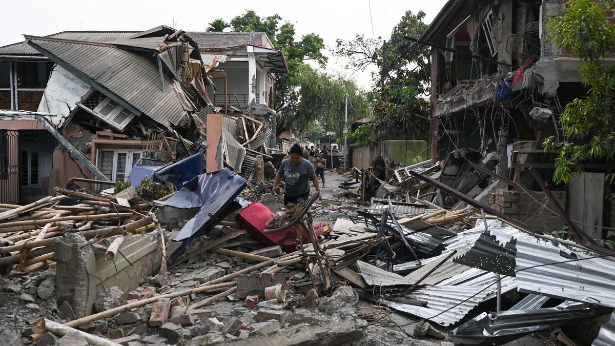
Manipur is no stranger to the scourge of massacres. In the infamous ‘Naga-Kuki clash’ of the 1990s, hundreds of innocents were slaughtered, not for what they did but because of who they were. In that protracted carnage amongst the ‘tribal’ communities of Manipur, places of worship and villages were razed to the ground and thousands rendered homeless. When it came to these Christian communities, the Biblical teaching ‘love thy neighbour’ was of no use in what was politically motivated genocidal violence. That spectre of a bloodbath has returned to haunt Manipur again, this time between the ‘Kukis’ and the Meiteis.
Incidentally, the ‘Kukis’ have been involved in such clashes with their neighbours across the years. Besides the infamous clash with the Nagas in the 1990s, there have been violent conflicts with the Dimasa (2003) and the Karbis (2004) in Assam, and with the Paites (1997-98) in Manipur.
So, what has led to this latest round of carnage involving the ‘Kukis’? Many commentators have mentioned the demand for Scheduled Tribe (ST) status by the Meiteis, and the attempt of the State government to ‘survey’ forest areas and ‘evict illegal’ occupants from the ‘protected forest’ being some of the ‘sparks’. But then, for the spark(s) to be produced and to turn into an inferno, there needs to be material. That material is the manufactured divide: the ‘hill-valley divide’ in Manipur. This contrived reality has to be taken as a historical a priori to understand the present carnage. For, it is a past that lives in the present and to borrow from Michel Foucault, ‘cast[s] a shadow’.
At the root of the divide is the invented topographical dichotomy between two geographical features of a landscape (viz., ‘hill’ and ‘valley’) belonging to the same elevated mountainous fold formed by the collision between the ‘Indian plate’ and the ‘Eurasian plate’. Imphal and the districts in Manipur (Churachanpur, Ukhrul, Chandel) and neighbouring States of Nagaland and Mizoram are parts of the same elevated mountainous fold, while the Brahmaputra valley is a part of the ‘depression’ created by the said collision.
The erstwhile Planning Commission classified States such as Nagaland, Manipur and Mizoram as ‘hill states’ while Assam was a ‘state with hill areas’. And yet, when one talks of ‘Imphal valley’ (790 metres) and its relationship with the ‘hills’ of Manipur (e.g., Churachanpur which is around 922 m), it is presented as if it is part of the same relationship that exists between the Brahmaputra valley/Guwahati (roughly 50 m) and Kohima (1,444m) or Aizwal (1,132m).
The British introduced this false topographical perspective in Manipur by extending a scheme that differentiated the Brahmaputra valley from the Naga and Lushai Hills in then Assam. However, the distinction brought about by the British was primarily in terms of ‘population’ rather than ‘territory’. Thus, while revenues were generated from both the hills and valleys in Manipur (e.g., house tax), the people were divided and governed under different regimes of law. Indeed, informed by the colonial anthropological episteme and strategic calculation, this geographical misrepresentation was further consolidated by classifying a section of the people as ‘hill tribes’ who were governed by a separate set of criminal and civil laws of the State of Manipur, irrespective of whether they lived in the hills or valleys.
The post-colonial Indian state, far from reversing the colonial schemes, has not only reproduced but also expanded these false dichotomies during the 1950s and early 1970s. Thus, the colonial category of ‘hill tribes’ has been re-rendered as ‘scheduled tribes’ (ST) and the rest as general category (later on, many of these people have been reclassified as Other Backward Classes) along with a small section, as Scheduled Castes. In fact, this has accentuated the division among the people by introducing a division of land though pieces of legislation such as the Manipur Land Revenue and Land Reforms Act, 1960 and Article 371C. Even the State legislature was also divided by introducing a ‘mini assembly’ — ironically called ‘Hill Area Committee’ — within the Assembly of a ‘hill State’.

Ranya Rao, caught smuggling gold at Kempegowda International Airport, claimed innocence, but agencies suspect syndicate involvement.

World Sleep Day: More than 26% of professionals said they are getting less than six hours of sleep in the night, a problem even more pronounced among entrepreneurs.

Samuel Browne's botanical explorations in 17th-century Madras offer insights into traditional plant uses and changing flora over time.

CPS Abolition Movement protests in Dindigul urging State government to implement old pension scheme promised by DMK.

Union Finance Minister criticizes removal of Indian currency symbol '₹' in Tamil Nadu Budget 2025-26 documents, citing national unity concerns.

State government provides ₹100 crore to KMRL for Kakkanad extension, speeding up construction and addressing funding issues.

ED joins probe into gold smuggling case involving Kannada actor Ranya Rao, raids multiple locations in Bengaluru.

Bombay High Court questions Maharashtra government on failure to register FIR against police officers in custodial death case.

Uttar Pradesh Minister Sanjay Nishad faces backlash for suggesting those who have issues with Holi colours should leave the country.

Tamil Nadu sees improved Olive Ridley turtle nesting season with over 2.5 lakh eggs collected, efforts to protect marine life.

Speeding bus crash on Paramakudi-Madurai highway kills woman, injures 23; driver flees scene, causing critical injuries.

Transport Minister flags off private and KSRTC buses from Goshree islands to Kochi city, improving public transportation.

TSPSC clarifies Group-I Mains exam evaluation process, releases key statistics, and addresses misinformation, ensuring fairness and transparency.