Tropical Storm Francine unleashes flooding rainfall and gusty winds as it drives into Louisiana
CNN
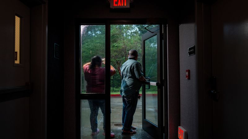
Francine made landfall along southern Louisiana as a Category 2 hurricane before weakening to a tropical storm and unleashing flooding rainfall and gusty winds on the region Wednesday night. The storm was the first hurricane to make landfall in Louisiana since 2021 and the third hurricane to make landfall in the US this year – the most since 2020.
Tropical Storm Francine inundated southern Louisiana with flash flooding that made roads impassable and caused power outages that left hundreds of thousands of customers in the dark early Thursday. The storm was the first hurricane to make landfall in Louisiana since 2021 and the third to make landfall in the US this year – the most since 2020. Here’s the latest: • Francine loses steam as it moves through Louisiana: The storm’s center was located about 20 miles northwest of New Orleans at 1 a.m. CT and was moving northeast at 14 mph. Francine made landfall in Terrebonne Parish as a Category 2 hurricane late Wednesday afternoon before weakening to a tropical storm late that night.Maximum sustained winds slowed from 100 mph at landfall to 50 mph by early Thursday, the National Hurricane Center said. Francine will progressively deteriorate as it tracks across west-central Mississippi into the Mid-South Thursday and Friday. “Life-threatening storm surge, considerable flash and urban flooding, hurricane-force winds and tornadoes are expected along the Louisiana, Mississippi and portions of the Alabama coastlines,” the National Weather Service said. The storm is forecast to spin down and become a tropical depression by late Thursday and a post-tropical cyclone Thursday night or early Friday. • Flooding in the New Orleans area: About 6-8 inches of rain fell in the New Orleans area, the National Weather Service said, and a flash flood emergency – meaning potential for catastrophic damage and a threat to life – was briefly issued Wednesday night for the area. A less severe flash flood warning for metro New Orleans was later issued and scheduled to be in effect until 1:45 a.m. CT Thursday. While no more rainfall was expected early Thursday, “the area is already being impacted by flash flooding,” the weather service said. In New Orleans, 90 of the 99 drainage pump systems – which can handle one inch of rainfall in the first hour and a half an inch after that – are operational, the city said in a news release. In St. James Parish, where 4-6 inches of rain fell, officials urged residents to stay off the streets as flooding from Francine churned water into homes. And in Jefferson Parish, officials implored residents to stay home and off of roads as “severe street flooding” created dangerous conditions. Elsewhere, Morgan City residents were asked to stay inside due to “unusual amounts of flooding.” • Strong winds also hit the region: Tropical storm warnings were in effect early Thursday along a southern swath of the Gulf stretching from Intracoastal City, Louisiana, to the Alabama-Florida state line, according to the NHC’s 1 a.m. CT advisory. Heavy rains and gusty winds were spreading across New Orleans, with sustained winds of 37 mph and gusts of 47 mph reported at Lakefront Airport. “We are getting consistent gusts of 55-65MPH across the metro and higher to the southwest,” the weather service in New Orleans said Wednesday evening. “Shelter in place and stay away from windows!” • At least 26 people rescued from floodwaters: Deputies in Lafourche Parish sprang into action Wednesday night to rescue 26 residents trapped in flooded homes, according to a statement from the Sheriff’s Office. Deputies will have an increased presence in the parish overnight as most of the area is without power, and a curfew in effect until 10 a.m. Thursday, officials said. • Damage to trees and infrastructure reported: Several parishes along Louisiana’s coastline reported downed trees and power lines as Francine lashed the area with damaging winds. Terrebonne Parish, where Francine made landfall, experienced power outages and toppled trees, Chief Communications Officer Robbie Lee said. Street flooding and downed trees were reported across Lafourche Parish, where there were over 25,000 power outages, a public information officer said. St. James Parish, slightly inland from the coast, had downed power lines, several transformers that blew, and a carport that flew off towards the roadway, the sheriff’s office said in a post on X. Jefferson Parish officials urged households to limit their water usage as the parish’s large and aging sewer system became overwhelmed by storm runoff.

This weekend’s gathering of young Republicans and conservative influencers in the Arizona desert offered a glimpse into the divisions already fraying President Donald Trump’s coalition even before its lame-duck leader is out of the picture.

The US is pursuing a vessel in international waters near Venezuela on Sunday after attempting to intercept it, a US official said, as President Donald Trump’s administration tightens its crackdown on the country’s oil industry.

Power was restored Sunday morning to the bulk of the 130,000 homes and businesses in San Francisco impacted by a massive outage on Saturday that caused major disruptions in the city.

When Rep. Dan Goldman first ran for Congress in 2022, he was cheered on the left as the party’s top lawyer during President Donald Trump’s first impeachment.

A dog desperately needing a potty break led Elaine Traverse to find a statue that had been the talk of the town in Canada’s Harbour Grace for months.

Police lights flashed for hours as law enforcement officers surrounded a storage facility in Salem, New Hampshire Thursday night, finally closing in on a suspect who unleashed deadly attacks on two communities and had managed to evade them for six days.

The National Transportation Safety Board is investigating after seven people – including former NASCAR driver Greg Biffle – died when a small private jet crashed shortly after takeoff in Statesville, North Carolina, this week, investigators said Saturday.

Personnel from the United States boarded and seized a vessel off the coast of Venezuela, according to an official familiar with the matter, as the Trump administration ramps up pressure on Caracas.

The Justice Department released thousands of files related to sex offender and accused sex-trafficker Jeffrey Epstein after Congress passed a law forcing the Trump administration to do so.

A judge Friday voided the conviction of one of the two men found guilty of the 2002 killing of Run-DMC star Jam Master Jay, ruling that there wasn’t enough evidence that the man had a motive to kill the hip-hop luminary.

It was like any other business trip for Minnesota frequent flyer Pete Carleton: walk through TSA, fill up the water bottle past security and chat with colleagues at the gate.

Many of the promises Trump made at Turning Point’s AmericaFest last year — including “lower prices,” an end to foreign wars and “generational change” — have yet to materialize.

In the hours after police discovered the bodies of Rob Reiner and Michele Singer Reiner inside their Brentwood, California, home, speculation was rife over what could have led someone to murder the beloved Hollywood director and his other half, a charismatic photographer and producer.