The implications of China’s mega-dam project | Explained
The Hindu
China's ambitious plan to build a mega-hydropower dam on the Brahmaputra river poses serious downstream implications for neighboring countries.
The story so far:
The ambitious plan to build a mega-hydropower dam across the Brahmaputra at the Great Bend region of the Medog county in the Tibetan Autonomous Region (TAR) in China, has been in the drawing boards of Chinese hydrocracy for decades. The clearest signalling to this effect happened in 2020 when this project was included in China’s 14th Five-Year Plan. Its approval was granted on December 25, 2024. India, Bhutan and Bangladesh will have serious downstream implications of this 60 GW hyper-dam built upstream by China.
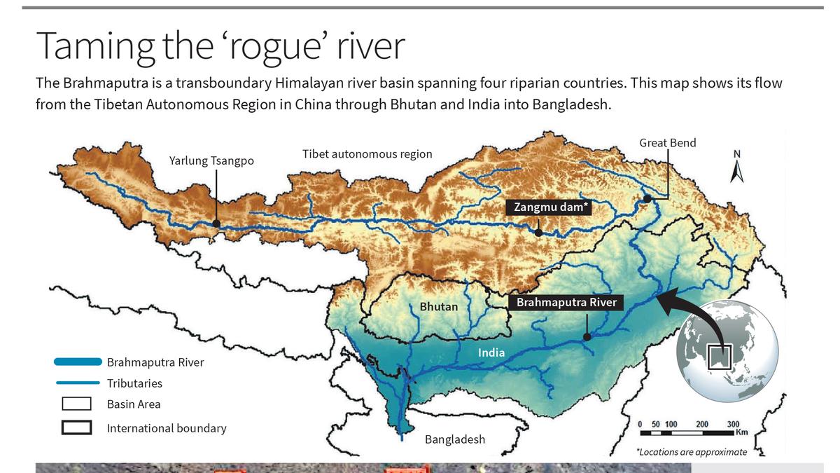
The Brahmaputra is a transboundary Himalayan river basin spanning four riparian countries. China is the uppermost riparian nation with the river system originating in the TAR, where it is known as the Yarlung Zangbo (or Tsangpo). India and Bhutan are lower riparian nations in relation to China and middle riparian countries in relation to Bangladesh. It is from Bangladesh, which is the lowermost riparian nation, that the river drains into the Bay of Bengal. All riparian countries have major water infrastructure projects planned in the river basin, such as hydropower dams, embankments meant for river control, irrigation dams and barrages.
Transboundary river systems are often likened by nation-states to ‘taps’, which they think can be closed or opened through hydraulic interventions such as dams within their respective nation-states. The Brahmaputra river system has been the site of planned and ongoing mega-dams projects by China, India and Bhutan, all contributing to an intense geopolitical power projection in the river basin. Mega-dams on rivers systems are seen as important sovereignty markers; symbols of nation-state control over natural features. Highly dramatised terms such as ‘water wars’ are part of the geopolitical vocabulary and upstream hydropower dams are viewed as ‘water bombs’ by lower riparian nations, as in the case of the Medog dam project. China sits pretty at the top of Asia’s water tower, with complete control over Tibet’s rivers and significant material, technological and discursive capabilities to deploy unilateral hydropower development.
The Chinese hydrocracy has gone forward with mega-hydropower developments such as the Three Gorges Dam on the Yangtze river and the Zangmu Dam on the Yarlung Zangbo, commissioned in 2015, with its top political leadership firmly backing these interventions as state symbols.
The communities living along the river system have adapted as the river has shaped and shifted over centuries. However, with interventions such as mega-hydropower dams by China, India and Bhutan, communities cannot use their traditional knowledge about the river system meaningfully, as the pace and occurrence of disasters have magnified. The upstream communities in Tibet as well as the downstream communities in India, Bhutan and Bangladesh have to live under the shadow of mega-hydropower dams with adverse consequences to their traditional lands and livelihood. The perennial flow of the Brahmaputra in downstream areas in India and Bangladesh depends on the flow of the Yarlung Zangbo. The blocking of that perennial flow, in order to maintain headwaters to operate a mega-hydropower dam of the magnitude that China is planning at the Great Bend, will have catastrophic consequences on surface water levels, and to overall monsoon patterns and groundwater systems of the river basin. This will affect downstream agrarian communities and the sensitive ecology of the overall Himalayan bioregion/ecoregion.
There is a face-off between China and India on the Yarlung Zangbo-Brahmaputra river course. China has announced the biggest hydropower project at the Great Bend while India has announced its largest dam project, at Upper Siang. Bhutan has been planning and building several medium to small dams, which have raised concerns in downstream India and Bangladesh. None of the riparian countries of the Brahmaputra river basin have signed the United Nations Convention on the Law of the Non-navigational Uses of International Watercourses of 2014, and hence first user-rights on river systems are non-enforceable. China and India have an Expert Level Mechanism (ELM) since 2006, to discuss outstanding issues and share hydrological data, but do not have a comprehensive bilateral treaty to govern shared transboundary rivers. The outstanding land boundary dispute between China and India is weaved into the intense securitisation of the Brahmaputra river basin, which makes it an active site for strategic posturing by both countries.


 Run 3 Space | Play Space Running Game
 Traffic Jam 3D | Online Racing Game
 Duck Hunt | Play Old Classic Game


