Rare 'triple-dip' La Niña could mean a wild winter ahead for Western Canada
CBC
CBC Alberta and Saskatchewan have teamed up for a new pilot series on weather and climate change on the prairies. Meteorologist Christy Climenhaga will bring her expert voice to the conversation to help explain weather phenomena and climate change and how it impacts everyday life.
Our climate has been steadily changing with a tendency toward warmer average temperatures, especially in recent decades.
But within that steady climb, of course, we have variations.
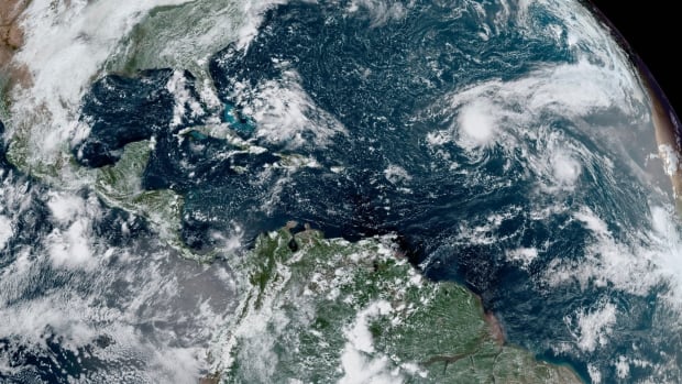
One of the biggest predictable swings in an area's climate has to do with El Niño and La Niña. In the Spanish language, the words mean little boy and little girl; in weather, they are climate patterns in the Pacific Ocean that can affect weather conditions around the world.
The climate kind of operates like a pendulum, swinging from El Niño conditions, through neutral ones, then to La Niña conditions. Sometimes the pendulum is faster, sometimes it's slower.
But what happens when the pendulum gets stuck?
We could find out this winter. Projections point toward the chance of a "triple-dip" — that is, third consecutive — La Niña winter.
We are in a La Niña situation right now and have had La Niña winters since 2020.
According to the latest report from the World Meteorological Organization (WMO), there is a 70 per cent chance for La Niña to continue through the summer and a 50-to-60 per cent chance it will continue to the end of the year and into another winter.
But what does that mean for our weather locally? And what about the million-dollar question: What role does climate change play?
La Niña means that the ocean waters at the surface in the eastern Pacific Ocean are running colder. It's the opposite of El Niño, where those water temperatures trend warmer.
The benchmark for declaring an El Niño or La Niña is half a degree over or under a long-term average but it can, of course, be more significant than that. Nonetheless, that innocent-sounding change can have a big impact on weather along the Pacific coast as well as globally.
According to the WMO, that ocean cooling can trigger changes in the tropical atmospheric circulation, predominantly with winds, pressure and rainfall.
"When there is a La Niña, it's normally followed by a kind of drought in East Africa and drought along the coastal area of the Gulf of Mexico. And floods in other parts of the world, for example, in West Africa," says Wilfran Moufouma Okia, head of the WMO's regional climate prediction services division in Geneva, Switzerland.

Egmont MP Bobby Morrissey says federal help for Prince Edward Island's struggling oyster fishery is expected early in the new year.

Calgary police have charged a man with defrauding numerous seniors out of about $186,000 in a string of incidents over a five-week period.

A Brampton lawyer allegedly connected to fugitive Ryan Wedding was granted bail Tuesday morning by the Ontario Superior Court of Justice.

Rankin Inlet hamlet councillors recently passed a motion that has had them avoid drinking alcohol for the 12 days leading up to Christmas, with the goal of setting a positive example for the community.

Jason Jacques says he learned a lot about the importance of choosing his words carefully in his first few months as the interim parliamentary budget officer (PBO).

Durham police say a man is dead after suffering multiple stab wounds in Oshawa Tuesday morning.

An internal review of technical outages that caused significant delays at airports and international land borders this fall has exposed critical flaws with the Canada Border Services Agency's IT services.

Two people are in life-threatening condition after being pulled from a house fire in Scarborough Tuesday morning, according to Toronto Fire Services.

Whenever the door opens at the British Grenadier Bookshop, proprietor Steve Douglas doesn’t know who is going to walk through.

A northeastern Ontario potato farmer says he’s shipping more bags of potatoes to southern Ontario to make up for waning demand.

Halifax’s registry of rental properties is now available to the public online, showing what HRM staff believe are the “bulk” of rentals in the city.

A New Brunswick tenant says he’s being pushed out of his rented bungalow as retribution for complaining about his landlord, but his landlord says she’s the victim of an unfair tenancy tribunal ruling that is preventing her from using the unit to house family.

Snow and freezing rain could affect morning commutes on Tuesday, according to a special weather statement issued by Environment Canada.