‘Near blizzard conditions’: Ontario braces for more lake-effect snow squalls
Global News
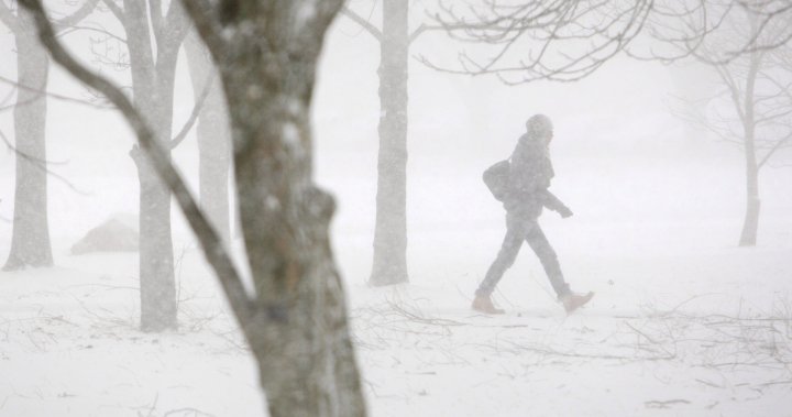
Ontarians seeking reprieve from a weekend blast of wintry weather will have to wait as another system is threatening “near blizzard conditions” for some parts.
Ontarians seeking reprieve from a weekend blast of wintry weather will have to wait as another system is threatening “near blizzard conditions” for some parts.
Global News meteorologist Anthony Farnell says an Alberta Clipper has been moving across the Great Lakes, bringing with it chilly winds and lake-effect snow squalls.
The system brought light snow on Wednesday, but come early Thursday morning, Farnell said winds will shift from the south to the northwest and the temperature will drop.
“Winds will remain brisk on Thursday, gusting over 50km/h at times,” he said.
“This wind, combined with snowfall rates as high as five-to-10 centimetres per hour will cause near blizzard conditions for some areas like London.”
With that warning in mind, both the Thames Valley District School Board and the London District Catholic School Board shut down their schools and buildings for the entire day Thursday.
The Ontario Provincial Police shut down Highway 402 in both directions from Highway 401 to Nauvoo Road due to whiteout and icy conditions. The 401 is also closed in both directions between Furnival and Currie roads in nearby in Elgin County.
Farnell said more than 30 cm could fall in the London area by Friday morning. Environment Canada said that figure could reach 30 cm as well, but if the system changes, it could be as high as 60 cm come Friday morning.

The results of the Leger survey suggest that Canadian and Americans hold many similar views on the state of the economy and their personal financial status.

International student enrolment at the University of Regina and the University of Saskatchewan is down, but by how much?

Higher power bill in the winter aren't uncommon, but some Nova Scotia Power customers opened their bills this month to find a shocking increase.

Donald Trump has said that he wants to “make the cars in Detroit,” indicating that he wants to replace Canada’s industry with a fully domestic American car industry.

In that response, UBC Properties Trust is not taking full responsibility.

The party said the Liberal Leadership Vote Committee unanimously disqualified Dhalla over 10 'extremely serious' rule violations it said were made.

The Canadian Civil Liberties Association and other advocate groups are urging the federal government to immediately pause the Safe Third Country Agreement.

A 15-year-old student in Alberta is taking what began as a school assignment into the real world.

Deputy Chief Devin Laforce and Deputy Chief Warren Driechel have been appointed to the shared role of interim chief.

Bank of Canada governor Tiff Macklem said the shock from U.S. tariffs would be very different from the economic downturn caused by the COVID-19 pandemic.

In an interview with Global News, Ruby Dhalla said she made a new request a week ago for a 'personal translator' but has yet to hear back from the party.

There has been one constant in Ontario this winter: a non-stop amount of snow that has left those responsible for clearing roads scrambling to keep up.

The City of Calgary is seeking feedback on a four kilometre Red Line LRT expansion south with two new stations at Silverado and 210 Avenue South.