


NASA releases first U.S. pollution map images from new instrument launched to space: "Game-changing data"
CBSN
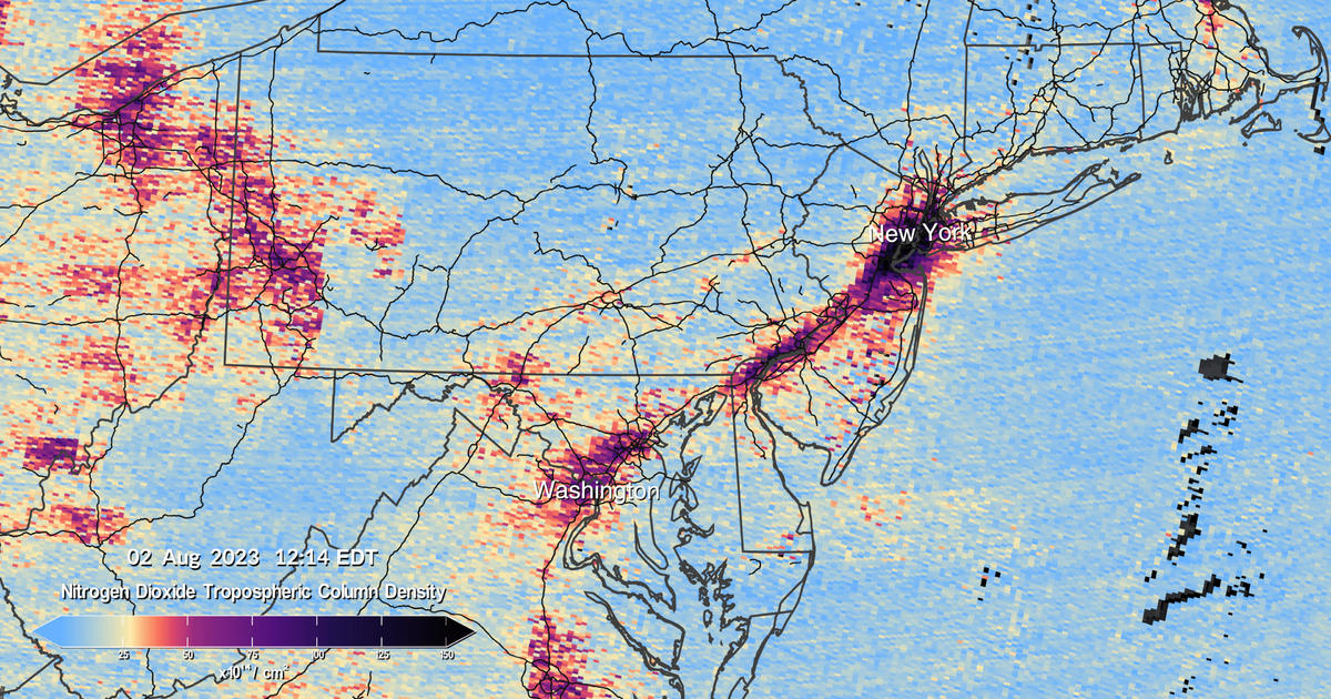
NASA has released the first data maps from a new instrument monitoring air pollution from space. The visualizations show high levels of major pollutants like nitrogen dioxide — a reactive chemical usually produced when fossil fuels are burned for transportation, power generation and other industrial activities, as well as wildfires — in the atmosphere over parts of North America.
Those images, which NASA compiled into a time lapse video and published on Thursday, pinpointed several urban areas in the United States, Canada, Mexico and the Caribbean as hotspots for air pollution, particularly during certain times of day. The pollution maps "show high levels of nitrogen dioxide over cities in the morning, and enhanced levels of nitrogen dioxide over major highways," the agency explained in a news release. Pollution dissipated in those areas in the early afternoon before ramping up again later as cities experienced "their second rush hour of the day."
The data used to create NASA's new air pollution maps was collected on August 2. High concentrations of nitrogen dioxide were detected over a number of U.S. cities and their surrounding regions, including Dallas, Houston, New Orleans, New York, Philadelphia and Washington, D.C.
 Run 3 Space | Play Space Running Game
 Traffic Jam 3D | Online Racing Game
 Duck Hunt | Play Old Classic Game
The Centers for Disease Control and Prevention is hiring Lyn Redwood, a nurse and the former head of a group critics have denounced as anti-vaccine, to work in its vaccine safety office, multiple CDC officials tell CBS News.

Washington — Kilmar Abrego Garcia, the Salvadoran man who was deported back to his home country and then returned to the U.S. for federal prosecution, is set to remain in jail for several more days as lawyers debate whether the Justice Department can stop him from being deported if he is released from federal custody pending his trial on human smuggling charges, according to The Associated Press.

Fortnite gamers who were charged for unwanted purchases while playing the online video game could receive a slice of the $126 million in refunds the Federal Trade Commission is sending out this week.

In-N-Out Burger is suing a popular YouTuber who it says posed as an employee of the burger chain and filmed his interactions with customers, later posting the videos online.

A group is ending a 20-year search for a plane that crashed into Lake Michigan in 1950, killing all 58 people on board, after sweeping the vast body of water using sonar technology and even getting support from an acclaimed adventure writer.

Top Justice Department official Emil Bove, who has been nominated for the federal appeals bench, testified before the Senate Wednesday that he never told department attorneys to ignore court orders, denying the account of a whistleblower.

An American Airlines flight returned to Las Vegas' airport Wednesday morning after flames and smoke came from one of its engines midair, officials said. The plane landed safely and no injuries were reported.

BP shares jumped as much as 10% after the Wall Street Journal reported that rival Shell is in early talks to acquire the British oil company.

Bumble will lay off roughly 30% of its workforce, or 240 employees, according to a regulatory filing filed by the online dating company on Wednesday.

Diamondbacks All-Star second baseman Ketel Marte was seen in tears on the field after a spectator yelled a derogatory comment about his late mother during an at-bat in Arizona's game against the White Sox on Tuesday night in Chicago.

The National Highway Traffic Safety Administration is investigating Tesla after incidents involving the electric car maker's robotaxis were caught on camera this weekend during a pilot in Austin, Texas.

President Trump is holding a news conference Wednesday to cap off the NATO summit in The Hague, Netherlands, amid a tenuous ceasefire between Israel and Iran.

A cargo ship that had been delivering new vehicles to Mexico sank in the North Pacific Ocean, weeks after crew members abandoned ship when they couldn't extinguish an onboard fire that left the carrier dead in the water.