


First images from NASA satellite which tracks climate changes released
CNN
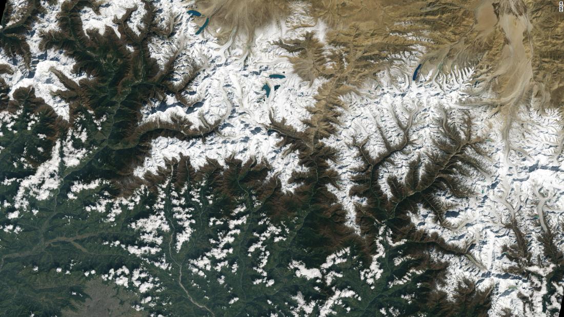
NASA has released the first snapshots of Earth taken with its new highly sensitive satellite which is designed to capture high-resolution images of the planet and help track the impacts of climate change.
NASA and the U.S. Geological Survey (USGS) have been collecting images of our planet using satellites since 1972.
The mission's most recent satellite, Landsat 9, launched in September this year, is equipped with two instruments that capture imagery and together provide experts with data about crop health, irrigation use, water quality, wildfire severity, deforestation, glacial retreat and, urban expansion.
 Run 3 Space | Play Space Running Game
 Traffic Jam 3D | Online Racing Game
 Duck Hunt | Play Old Classic Game
When Small Business Administrator Kelly Loeffler touted that her agency guarantees approximately 2,000 small business loans every week, Laura Pager, a small business contractor who says she has lost out on millions of dollars in work this year in the wake of the Department of Government Efficiency’s slashing of the federal government, wrote it down in disbelief.

Prosecutors will take “no further action” against a Florida sheriff’s deputy in the arrest of a Black college student pulled from his car and beaten by officers during a February traffic stop.

FBI agents – thrust into yet another role for which they are not trained – have been put on patrol duties with local police as part of President Donald Trump’s declaration of a crime emergency in Washington, DC.

A failed political candidate was sentenced to 80 years in federal prison Wednesday for his convictions in a series of drive-by shootings at the homes of state and local lawmakers in Albuquerque in the aftermath of the 2020 election.

A man was charged Wednesday after allegedly throwing a sandwich at a federal law enforcement officer in Washington, DC, amid President Donald Trump’s takeover of the city’s police and increase in federal law enforcement presence.

President Donald Trump has often bragged about his warm relationship with Russia’s Vladimir Putin. But in the months leading up to the leaders’ first meeting in six years, Trump began asking Europeans and White House aides what’s changed about his counterpart.

Mexico sent 26 alleged cartel figures to face justice in the United States because the Trump administration requested them and Mexico did not want them to continue running their illicit businesses from Mexican prisons, officials said Wednesday.

The story of President Donald Trump’s first seven months back in office is the consolidation of power.

A judge in Illinois on Wednesday denied Texas Attorney General Ken Paxton’s request to enforce civil arrest warrants for the absent Texas House Democrats trying to stop a redistricting effort that could net Republicans five seats in the US House.

CNN’s 5 Things PM brings you the stories you might have missed during your busy day.

President Donald Trump has been unable to negotiate a peace deal between Ukraine and Russia, despite vowing to end the war on Day One of his second term. He’s hoping a highly anticipated sit-down with Russian President Vladimir Putin will help change that.

A federal judge in San Francisco seemed unconvinced after a three-day trial that the continued deployment of federalized members of California’s National Guard — who were originally deployed to Los Angeles in response to protests against President Donald Trump’s immigration agenda — is lawful.

Democrats are banking in a big way on California and its governor, Gavin Newsom, to help them fight back against Republicans in a burgeoning gerrymandering arms race.