Beryl Set To Rapidly Intensify On Approach To Texas Due To Hot Ocean Temperatures
HuffPost
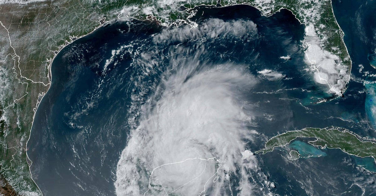
The waters in the Gulf of Mexico are warm enough for the early-season storm to rapidly intensify, as it has several times before.
With its unprecedented tear through the ultrawarm waters of the southeast Caribbean, Beryl turned meteorologists’ worst fears of a souped-up hurricane season into grim reality. Now it’s Texas turn.
Beryl hit Mexico’s Yucatan Peninsula as a Category 2 hurricane on Friday, then weakened to a tropical storm. It’s expected to reach southern Texas by Sunday night or Monday morning, regaining hurricane status as it crosses over the toasty Gulf of Mexico.
National Hurricane Center senior specialist Jack Beven said Beryl is likely to make landfall somewhere between Brownsville and a bit north of Corpus Christi Monday. The hurricane center forecasts it will hit as a strong Category 1 storm, but wrote “this could be conservative if Beryl stays over water longer” than expected.
The waters in the Gulf of Mexico are warm enough for the early-season storm to rapidly intensify, as it has several times before.
“We should not be surprised if this is rapidly intensifying before landfall and it could become a major hurricane,” said Weather Underground co-founder Jeff Masters, a former government hurricane meteorologist who flew into storms. “Category 2 may be more likely but we should not dismiss a Category 3 possibility.”

The Democratic campaign has been less focused on Trump’s election denial, but Trump inserts it into the news cycle all on his own.

The former president's "I'm not going to tell you what to do" admission drew backlash on social media.

The lifelong Republican's zing came during a joint rally appearance with Donald Trump's Democratic rival Kamala Harris.

The two appeared near the birthplace of the GOP as Harris pitches herself to moderate and conservative voters.

The briefing may have been 165 pages, but there are three key points the special counsel has made for Judge Tanya Chutkan’s consideration that stand out.

Rep. Tim Burchett (R-Tenn.) made the antisemitic remark about the financier while discussing radio station ownership on Fox News.

Hurricane season ends Nov. 30. Another hurricane is expected to hit, said Homeland Security Secretary Alejandro Mayorkas.

Many people wondered if the clip to promote the former first lady's upcoming memoir was actually a campaign ad for her husband's opponent.

The former president has spread racist lies about the Ohio community despite pleas from local officials to stop doing so.

Alyssa Farah Griffin served as White House communications director under Donald Trump, and is thus well aware of what he did and didn't do while in office.

Richard Rogers called the former House speaker’s office more than 100 times after becoming upset that the balloon had not been shot down.